Our Motivation
There are more than 500 million smallholder farmers cultivating less than 2 hectares of land worldwide. Although these smallholders are the cornerstone of local food security and local economies, many are highly vulnerable to climatic events such as extreme precipitation, hurricanes, and droughts. In response to requests by small farming communities in northern Nicaragua, and in partnership with a local community development organization CII-ASDENIC, a collaboration between members of the Frugal Innovation Hub, the Department of Civil, Environmental, and Sustainable Engineering, the Department of Environmental Studies and Sciences, and the Department of Art and Art History, have developed a mobile phone application called “NicaAgua.”
Our Approach
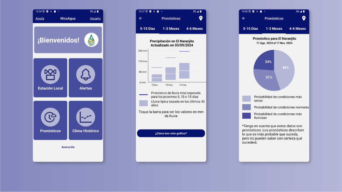
By utilizing human-centric design and frugal innovation principles, we developed a mobile phone application called NicaAgua with and for our partner organization CII-ASDENIC. Its basic capabilities are: uploading and sharing timely data from a local weather station, broadcasting weather and water information such as flood warnings, storing historical weather data to allow comparisons of precipitation and temperature data from the last 40 years, and visualizing community-scale short and medium-term climate forecast data to better prepare farmers for crop planting and harvesting given weather variations and climatic changes. Visual and interpretative information explains whether current weather is outside of the expected range. The NicaAgua app features an intuitive and user-friendly interface, designed to provide a seamless experience for users in accessing crucial weather information. The overall design of the user interface prioritizes ease of navigation and accessibility, ensuring that users can quickly find the information they need.
Our Results
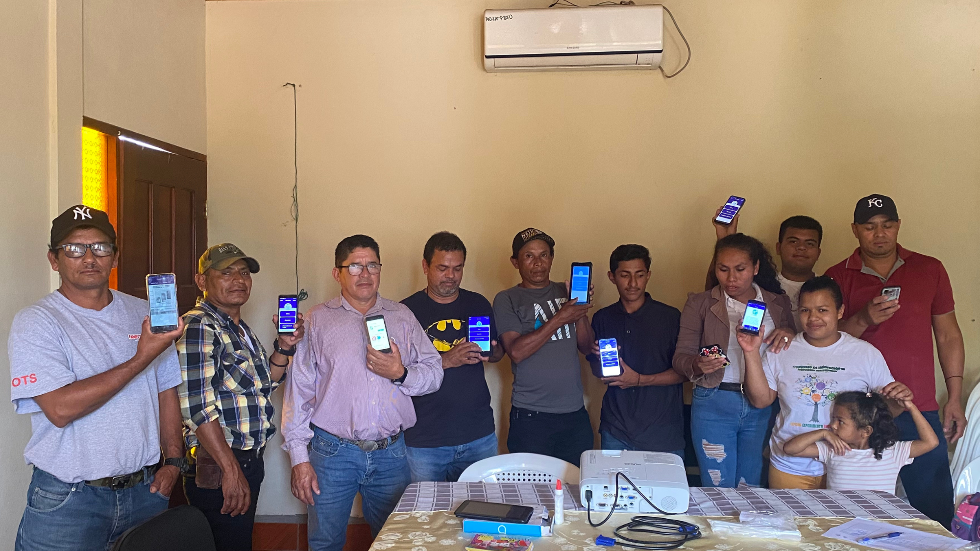
The NicaAgua app has 3 core functionalities: live weather updates from a local weather station, a broadcast message system for critical water alerts, and access to short-term local weather forecast information from the UC Santa Barbara’s Climate Hazards Center Infrared Precipitation with Stations (CHIRPS), as well as longer-term forecasts. The app has been tested by our collaborators at CII-Asdenic and by smallholder farmers at workshops and focus groups. A Beta version was released in September 2023 in the Google Play Store. No Apple version is currently available.
Our Latest Functionality
Understanding how weather patterns have shifted over the years can be invaluable, particularly for farmers. Observing long-term trends helps visualize the impact of climate change and enables farmers to make more informed decisions. By incorporating these larger patterns, they can better predict and plan for future conditions.
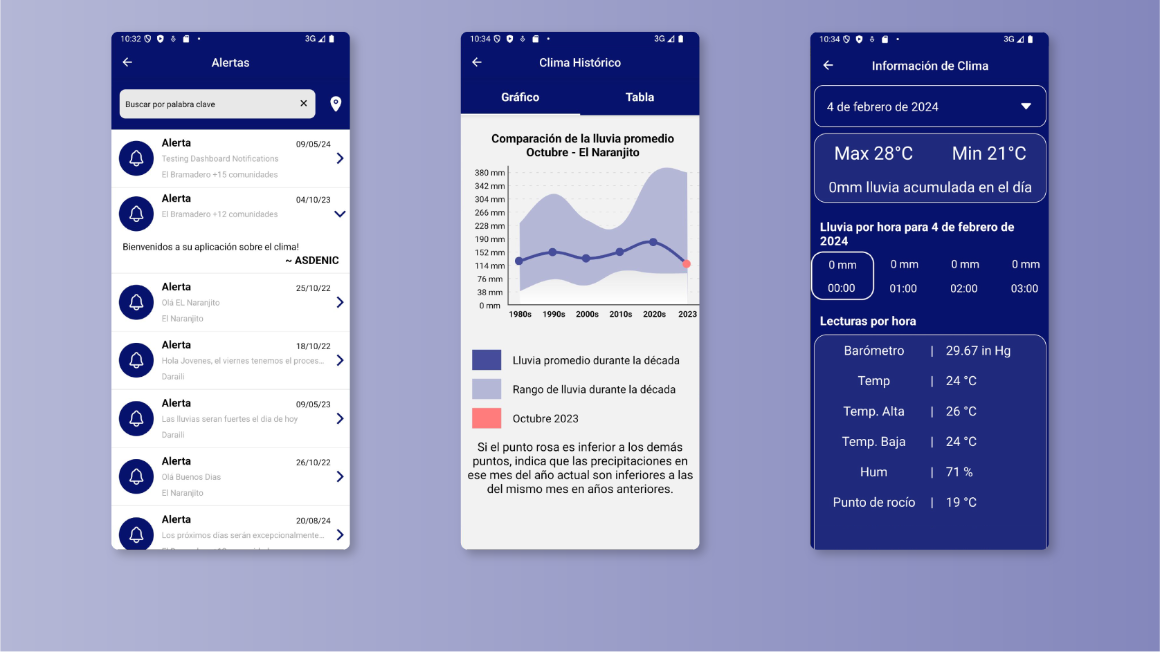
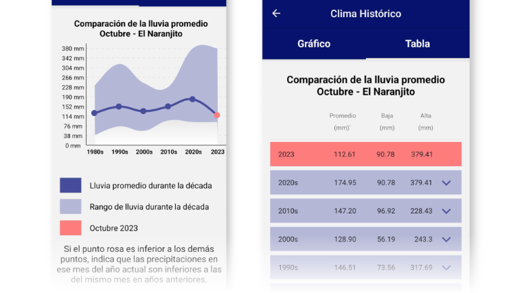
To support this, NicaAgua has developed the 'Comparison Functionality.' This feature allows users to select a specific month and access historical weather data for their community spanning the past 40 years. The data is presented in both graph and table formats, providing a simple and intuitive way to interpret the information, tailored to the needs and preferences of different users."
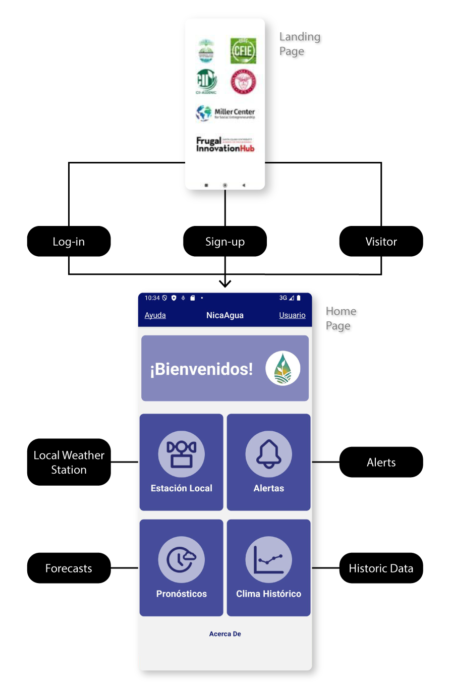
App structure.
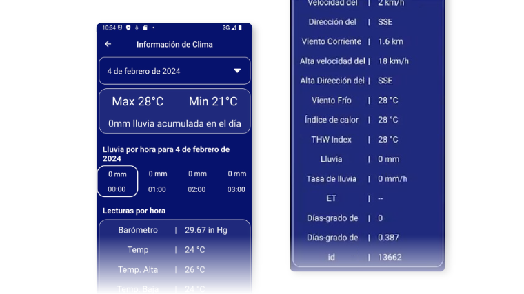
Local Weather Station
Through a customized website designed by FIH students specifically for this project, CII-ASDENIC can share live, hourly weather data from a local weather station with users of the NicaAgua app. Users can access this information by selecting the "Estación Local" feature within the app. They can choose the desired month and day, and then view weather data for a specific hour. Available information includes precipitation, wind speed and direction, dew point, temperature, and the expected high and low temperatures, among other data.
Impact:
- No need to wait for weekly community meetings to access local weather station updates.
- Easy access to daily and hourly weather information.
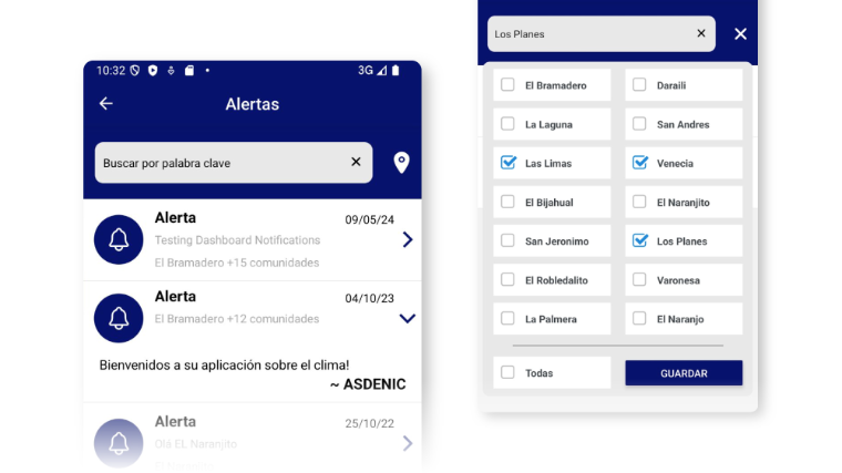
Alerts
Through the same customized admin platform used for weather station updates, CII-ASDENIC can send tailored alerts about extreme weather conditions, warnings, and community weather updates to NicaAgua users. Alerts can be sent to all users or targeted to specific communities. Red alerts, indicating urgent situations, are accompanied by a red bell icon.
Impact:
- Community-based flood warning system.
- Sharing of community best practices.
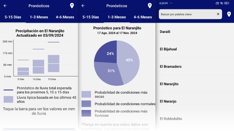
Forecasts
Using this feature, NicaAgua app users can view two types of weather forecasts: short-term and long-term. Short-term forecasts provide predictions for 5, 10, and 15 days. Long-term forecasts cover 1–3 months and 3–6 months. Forecast data is displayed in an intuitive, interactive graph. Users can read an automatically generated interpretation of the graph, view total expected precipitation, and access community-specific data. Additionally, the app can send automatic pop-up alerts for forecasts that deviate significantly from 40 years of expected precipitation patterns, warning users about exceptional weather conditions.
(See the weather science behind this feature)
Impact:
- Community-specific forecast information supports agricultural decision-making.
- Enables agricultural cycle planning, including activities such as planting, pruning, soil erosion control, and fertilization.
Historic Data
The "Clima Histórico" (Historic Weather) is our newest feature requested by users in multiple of our community workshops. This feature enables users to compare precipitation and temperature data over the past 40 years to better understand climate variability. This data can be visualized in two formats: A graph showing variability every 10 years and as a table showing both yearly and 10-year variability.
Impact:
- Visual representation of climate variability.
- Increased awareness of climate change impacts.
